
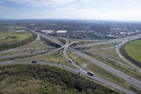
South Gloucestershire Council has published further details of plans to create a near-continuous, two-way segregated cycle track along the full length of Bradley Stoke Way.
The 3m-wide track is part of a suite of proposals to improve walking, cycling, wheeling, and bus travel between Thornbury and south Bradley Stoke.
Despite only 32 percent of respondents to the Phase 1 public consultation expressing support for the wider scheme, council planners have chosen to progress to a Phase 2 public consultation, which is now open and runs until 18th December 2023.

For the Bradley Stoke Way section of the scheme, the latest consultation material adds further details of the proposals for Patchway Brook Roundabout (near Aldi), Savages Wood Roundabout (near the leisure centre) and Stoke Brook Bridge (over the nature reserve).
Funding for the proposed scheme is being provided by central government via the West of England Combined Authority. Cost estimates are being developed as part of the design process, with a current projection of £31.8 million. The capital funding from the government cannot be used for other purposes and the council warns that the money would have to be handed back should it decide not to proceed with the scheme.
Introduction: Bradley Stoke Way
Editor’s note: In the descriptions below, Bradley Stoke Way is considered to run north-south through its entire length, so ‘western side’ refers to the Willow Brook Centre side and ‘eastern side’ refers to the Bradley Stoke Leisure Centre side.
The proposals for Bradley Stoke are:
- A new, separate two-way cycleway to free up more space for pedestrians and make it safer for everyone
- Additional pedestrian crossing points along Bradley Stoke Way to make it easier for pedestrians and wheelchair users to get where they need to go
- Revised speed limits to make getting around safer for everyone
- Improvements to bus stops along the route to make traveling by bus a more pleasant experience
Willow Brook cross-over
The new two-way cycle track will generally run on the western side of Bradley Stoke Way, however, in the vicinity of the Willow Brook Centre it will cross over to run on the eastern (leisure centre) side for about 290m before returning to the western side. Council officers say this diversion is needed because of a shortage of space on the Willow Brook side of the road, which currently accommodates a narrow shared-use path.
Cyclists following the cross-over route will need to traverse two signal-controlled crossings, adding time to their journeys, however the council has confirmed to the Journal that the existing shared-use path on the Willow Brook Centre side will be unaltered, so cyclists could choose to continue on the western side of the road and re-join the new dedicated cycle track 290m further down the road. This will also ensure that cyclists can continue to access the shopping centre without having to dismount and walk for a distance of up 200m.
New crossings
| Crossing type | Description |
|---|---|
| Puffin crossing | This is a stand-alone signal-controlled pedestrian crossing. |
| Parallel crossing | This consists of a zebra crossing alongside a separate cycle crossing. This type of crossing gives pedestrians and cyclists priority at crossings, improving their safety. |
| Signalised parallel crossings | These are signal-controlled crossings where pedestrians and cyclists are separated. |
| Toucan crossings | These are signal-controlled crossings shared between pedestrians and cyclists with no separation between them. A shared use path is suitable on either side of these crossings to avoid conflict among users. |
Above: Types of crossing used in the proposals for Bradley Stoke Way.
The proposals would see parallel pedestrian and cycle crossings installed on all arms of four roundabouts on Bradley Stoke Way: Patchway Brook, Savages Wood, Webbs Wood and Great Meadow (a.k.a Baileys Court). These crossings are signal-controlled on all of the Bradley Stoke Way arms and some of the side road arms. Other side road arms will have a zebra crossing and a parallel cycle crossing on a raised table.
A new signal-controlled (puffin) crossing is also proposed on Bradley Stoke Way at a point just north of Stoke Brook Bridge, to provide safer pedestrian access to the bus stop known as ‘The Bridge (S-Bound)’.
The new crossings would mean that motorists travelling the full length of Bradley Stoke Way, from Great Stoke Roundabout to the Aztec West Roundabout will pass through at total of 14 signal-controlled junctions or pedestrian/cyclist crossings, an increase of eight on the current six.
Bus stop upgrades
The bus stops that will be upgraded to have shelters and improved accessibility are those known as ‘Savages Wood Roundabout’ (N-Bound and S-Bound) and ‘The Bridge’ (N-Bound and S-Bound). These are currently served by the T1 service only.
Bridge bottleneck
.")
The limited width of the Stoke Brook Bridge means that a segregated cycle track cannot be accommodated at this location so the cycleway and footpath will merge into a shared-use path for a short distance.
The road width will be reduced to 6.4m over the bridge and the parapet height will be increased to 1.4m.
Approach lanes reduced
The Bradley Stoke Way southbound approach to Savages Wood Roundabout currently provides two traffic lanes at the entry to the roundabout, with the left lane being for ‘left turn or straight on’ (first or second exits) and the right lane being for ‘right turn’ (third exit).
The consultation drawings show this carriageway being reduced to a single lane at the entry to the roundabout.
The Bradley Stoke Way northbound approach to Savages Wood Roundabout currently has a single marked traffic lane with a wide white diagonal line hatched area to the left side. At present, many motorists use the hatched area as an unofficial ‘left turn’ lane, but this will no longer be possible if the proposals are implemented as the carriageway will be significantly narrowed at this point.
The same narrowing is proposed for the Savages Wood Road approach to Savages Wood Road Roundabout, where many motorists also use the hatched area as an unofficial ‘left turn’ lane.

Speed limit changes
A proposal in the Phase 1 consultation to reduce the speed limit over Stoke Brook Bridge from 40mph to 30mph by extending the existing 30mph limit further south from Savages Wood Roundabout has been dropped.
Instead, the council says it is now aiming to “provide a consistent speed limit along Bradley Stoke Way, where possible”. To this end, the current consultation proposes to increase the speed limit south of Great Meadow Roundabout up to Great Stoke Roundabout from 30mph to 40mph.
A council spokesperson told the Journal:
“The change in speed limit aims to improve traffic flow along this section. This will be particularly beneficial in reducing bus journey times along this section.”
In detail: Bradley Stoke
.")
The above map may be viewed in higher resolution on the ‘Bradley Stoke way map‘ consultation document [PDF, 1.1MB] or as a JPEG file [634kB] on Dropbox.
Editor’s note: In the descriptions below, Bradley Stoke Way is considered to run north-south through its entire length, so ‘western side’ refers to the Willow Brook Centre side and ‘eastern side’ refers to the Bradley Stoke Leisure Centre side.
Aztec West Roundabout
Key proposals include:
- Two-way cycle track and footway to south of Aztec West Roundabout
- Upgrade of existing pedestrian crossing on A38 Gloucester Road
? View technical drawing for this section [PDF]
Aztec West Roundabout to Patchway Brook Roundabout
Key proposals include:
- Two-way cycle track and footway along western side of Bradley Stoke Way
- Improved crossings at Woodlands Lane junction
- Bus stop ‘Aztec West Roundabout (D)’ relocated
? View technical drawing for this section [PDF]
Patchway Brook Roundabout

The above map may be viewed in higher resolution in the ‘BSW Patchway Brook roundabout‘ technical drawing [PDF, 1.1MB] or as a JPEG file [784kB] on Dropbox.
Key proposals include:
- Two-way cycle track and footway along western side of Bradley Stoke Way
- Improved walking and cycling crossings across all arms of Patchway Brook Roundabout [1]
- Bus stop by-pass at the existing MetroBus stop south of Patchway Brook Roundabout known as ‘Patchway Brook NW-Bound’.
[1] All five crossings here will be signal-controlled parallel crossings. The pedestrian element of the crossings on the Bradley Stoke Way arms will be two-stage.
Patchway Brook Roundabout to Savages Wood Roundabout
Key proposals include:
- Two-way cycle track and footway along western side of Bradley Stoke Way
- Two-way cycle track crosses to eastern side of Bradley Stoke Way to avoid narrow section outside Tesco and improve connections to Community School and Leisure Centre
- Upgrade of existing pedestrian crossing on Bradley Stoke Way near McDonald’s [2]
[2] The crossing near McDonald’s will be upgraded from a two-stage puffin crossing to a two-stage toucan crossing.
? View technical drawing for this section [PDF]
Savages Wood Roundabout

The above map may be viewed in higher resolution in the ‘BSW Savages Wood roundabout‘ technical drawing [PDF, 1.0MB] or as a JPEG file [667kB] on Dropbox.
Key proposals include:
- Two-way cycle track and footway along eastern side of Bradley Stoke Way, crossing back to western side to the north of Savages Wood Roundabout
- New southbound bus lane along Bradley Stoke Way approaching Savages Wood Roundabout
- Upgrade of existing pedestrian crossing on Bradley Stoke Way near the leisure centre [3]
- Improved walking and cycling crossings across all arms of Savages Wood Roundabout [4] [5]
[3] The current toucan crossing near the leisure centre will be moved closer to Savages Wood Roundabout (and so no longer align with the footpath out of the leisure centre) and become a signalised parallel crossing. The pedestrian element of this crossing will be two-stage.
[4] The crossings on the Savages Wood Road and Fiddlers Wood Road arms of the roundabout will be parallel zebra crossings on raised tables.
[5] The crossing on the Bradley Stoke Way arm to the south of the roundabout will be a signalised parallel crossing.

Savages Wood Roundabout to Webbs Wood Roundabout
Key proposals include:
- Two-way cycle track and footway along western side of Bradley Stoke Way
- Bus stop improvements, including bus stop by-pass at the northbound bus stop north of Stoke Brook Bridge
- New crossing linking the bus stops known as ‘The Bridge’ on either side of Bradley Stoke Way [6]
[6] This will be a signal-controlled (puffin) crossing for pedestrians.
? View technical drawing for this section [PDF]
Webbs Wood Roundabout

The above map may be viewed in higher resolution in the ‘BSW Webbs Wood roundabout‘ technical drawing [PDF, 1.0MB] or as a JPEG file [710kB] on Dropbox.
Key proposals include:
- Two-way cycle track and footway along western side of Bradley Stoke Way
- Improved walking and cycling crossings across all arms of Webbs Wood Roundabout [7] [8]
- Removal of bus stop north of Webbs Wood Roundabout known as ‘Webbs Wood Roundabout NW-Bound’ (previously used by the 73 service)
- Bus stop by-pass at the existing MetroBus stop south of Webbs Wood Roundabout known as ‘Webbs Wood NW-Bound’.
[7] The crossing on the Bradley Stoke Way arms of the roundabout will be signalised parallel crossings.
[8] The crossings on the Webbs Wood Road arms of the roundabout will be parallel zebra crossings on raised tables.
Great Meadow (a.k.a. Baileys Court) Roundabout

The above map may be viewed in higher resolution in the ‘BSW Baileys Court roundabout‘ technical drawing [PDF, 1.1MB] or as a JPEG file [729kB] on Dropbox.
Key proposals include:
- Two-way cycle track and footway along western side of Bradley Stoke Way
- Improved walking and cycling crossings across all arms of Great Meadow Roundabout [9] [10]
- Bus stop improvements, including bus stop by-pass, at the existing MetroBus stop south of Great Meadow Roundabout known as ‘Great Meadow NW-Bound’
[9] The crossings on the Bradley Stoke Way arms of the roundabout will be signalised parallel crossings.
[10] The crossings on the Baileys Court Road arms of the roundabout will be parallel zebra crossings on raised tables.

Great Meadow Roundabout to Great Stoke (a.k.a. Rabbit) Roundabout
Key proposals include:
- Two-way cycle track and footway to run along western side of Bradley Stoke Way
- Improved walking and cycling crossing at The Worthys junction [11]
[11] The crossing over the mouth of The Worthys junction will be a parallel zebra crossing on a raised table.
? View technical drawing for this section [PDF]
Responses to previous concerns
A ‘Further information’ document included as part of the current consultation states:
“We recognise there were concerns raised in our previous consultation about the design of the scheme, particularly from people who live directly on the route, worried about potential disruption.”
“These concerns are understandable, and the council is doing all it can to minimise and mitigate impact so that we can deliver the wider benefits, which so many local people have told us they want.”
“Previous opposition to the scheme has primarily focused on how this scheme would be paid for and whether this money could be spent on other things.”
The document provides the following responses:
Concern: I want my council tax money to be spent on other things.
Response: No council tax money is being spent on this scheme. Funding comes from Central Government on the pre-condition that money must be spent on measures to encourage cycling and active travel.
If we do not proceed with this scheme, money would be returned to Central Government so it could be spent on improvements elsewhere.
Concern: There aren’t enough pedestrians/cyclists to warrant this investment
Response: There is already a well-used shared use path for pedestrians and cyclists on Bradley Stoke Way; the proposals involve creating a separate cycle lane to improve safety.
Safety concerns are often one of the main barriers to active travel and from our initial engagement work, we believe there are many more people who would travel more actively if these improvements went ahead.

Maintenance funding
A presentation about the proposed scheme was given at the virtual meeting of the Bradley Stoke Stoke Lodge and The Common Community Engagement Forum held on 21st November 2023.
Journal editor Stephen Horton asked what consideration has been given to ongoing maintenance costs of the £31.8m scheme post-completion, with reference to the poor state of the current shared-use path along Bradley Stoke Way and the Concorde Way route that links with it. Reference was made to uneven surfaces, overhanging brambles and tree branches and the lack of leaf clearance in autumn and gritting in winter.
The presenter, Tom Lacey, principal project manager, replied:
“The money from the government has to to be used by March 2027. That means that all the funding has to be used for improvements or new infrastructure. So unfortunately there is not any directly related maintenance or upkeep funding at this point. Hopefully there will be supportive funding in the future, however there are no guarantees at this point.”
“I think you’re aware of the current position, in terms of the budgetary constraints of the council and a number of other councils at this point in time.”
“Unfortunately this project is purely infrastructure-funded and we will be making an assessment as part of the scheme in terms of understanding the impact for the future in terms of additional traffic signals, bus shelters etc. in terms of revenue and maintenance funding requirements.”
Have your say
For further information or to participate in the feedback survey visit the Phase 2 public consultation webpage:
A38, Alveston Hill and Bradley Stoke Way active travel improvements (SGC)
The above webpage links to a dedicated website that presents all of the consultation information and offers the opportunity to provide feedback:
Have Your Say Today – A38, Alveston Hill And Bradley Stoke Way Active Travel Improvements (Commonplace)
The consultation is open until midnight on Monday 18th December 2023.
If you have any questions about the consultation or feedback survey, please email consultation@southglos.gov.uk
Related links:
- Cycle Infrastructure Design [PDF, 16.9MB] (Department for Transport)
- Public Consultations (The Journal)
Town council’s view
Members of Bradley Stoke Town Council’s Planning & Environment Committee agreed at their meeting on 22nd November 2023 to submit the following responses to the Phase 2 public consultation:
- Councillors are in favour of creating separate cycle lanes for road users but the proposed configuration of the cycle arrangements around the main town centre roundabout [Savages Wood Roundabout] on Bradley Stoke Way is inappropriate and should be addressed properly or not done at all.
- There are budgetary concerns as to whether long-term maintenance funding has been identified from either South Gloucestershire Council or central government. Although the responsibility to maintain the new scheme may not fall to Bradley Stoke Town Council, it may be necessary for the town council to step in and pay for remedial works in the future.
- Councillors are in favour of improvements to the bus stops along Bradley Stoke Way to make bus travel more attractive which may, in turn, encourage more people to use public transport.
- Councillors are in favour of introducing new crossings to allow pedestrians to cross the roads safely, but traffic light timings need to be relevant to road type and speed of vehicles.
- Councillors feel that the speed restrictions need to be consistent along the entire road.
What happens next?
From the ‘Answers to your questions’ document included as part of the Phase 2 public consultation:
The decision process
Funding is subject to business case approval by the Combined Authority. An Outline Business Case was submitted and approved in summer 2022. A Full Business Case will be submitted to the Combined Authority during 2024 following the completion of detailed design, which will be informed by the responses received during this public consultation.
When could construction take place and how long might it last?
Should approval of a Full Business Case be granted by the Combined Authority, construction would likely commence in 2024 or 2025. We anticipate that works may take two years to complete. Our contractors would take every possible step to minimise disruption. Given the length of the route, it is likely that works will be phased so only certain sections will be worked on at any one time although to meet funding requirements potentially more than one phase will be worked on during the same period.
How will roadworks during construction affect journeys?
Should the project go ahead, we would organise work to minimise disruption to traffic and maintain access to properties along the corridor. This needs to be balanced with ensuring safety for the public and workforce around work sites but we will continue to work with residents and businesses throughout the construction phase.
For most of the A38 route, the proposals to create a two-way cycle track on just one side of the road will result in less disruption than if segregated cycle tracks were to be provided on both sides of the road. Where safe to do so, two-way traffic flow will be maintained through sections of roadworks but with reduced speed limits and lane widths. However, this will not be possible all the time and temporary traffic lights will be used where necessary for safety reasons to restrict traffic to shuttle working.
The works required along Bradley Stoke Way will affect the existing footpath/shared-use path along with some works on the carriageway and improvements to the existing roundabouts as shown on the engineering drawings.
Due to a technical issue, the online consultation closed a few hours before midnight on Monday (18th December 2023). If you were unable to submit your feedback because of this, please contact consultation@southglos.gov.uk